
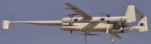
BDPT-EHF-FL58 Aerial Geophysical Survey UAV
BDPT-EHF-F58 Aviation Geophysical UAV is a 60KG-class industrial-grade hybrid electric VTOL fixed-wing aircraft. It integrates an aeromagnetic compensator, cesium vapor magnetometer, and fluxgate magnetometer, capable of surveying up to 500KM per flight. Compared to manned aeromagnetic surveys, it offers higher precision, efficiency, maneuverability, lower costs, and an intuitive ground control station with automatic route planning for takeoff and landing—fully autonomous operation. Industry Applications: Widely used in basic geological surveys, mineral resource exploration, ecological geology investigations, anti-submarine operations at sea, and naval magnetic radiation detection across multiple sectors.
Product Specifications
Project | Parameters | |
Wingspan | 4.5m | |
All Captains | 3.63m | |
Maximum Takeoff Weight | 58kg | |
Takeoff and Landing Method | Vertical Takeoff and Landing | |
Powertrain | Gas/Diesel Engine | |
Cruise Speed | 100~115 km/h | |
Maximum Speed | 160Km/h | |
Practical Cruise Altitude | 1000–3000m | |
Maximum Ceiling | 4000m | |
Maximum Takeoff Altitude | 3000m | |
Battery Life | 4h | |
Maximum Payload | 12kg (fuel + payload) | |
Maximum Range | 400 km | |
Wind Resistance | 6 Level | |
Payload Compartment Volume | 500mm x 320mm x 220mm | |
Operating Temperature | -20~+50°C | |
Compact Yandeng Pump Magnetometer | ||
How it works | Self-oscillating bifurcation beam bright light pump (non-radioactive Cs-133) | |
Scope of Work | 10000~10000 | |
Gradient Difference | 40000 nT/m | |
Applicable Region | 15°~75° and 105°~165° | |
Sensitivity | 0.0006nTVHz(rms) | |
Noise Level | Typical peak-to-peak 0.002nT, bandwidth 0.1 Hz | |
Absolute Accuracy | <25nT Full Scale | |
Operating Temperature | -40~+50C | |
Miniature High-Sensitivity Airborne Magnetic Compensator | ||
1 adopts the T-L model, ultra-high-precision counting module, and clock synchronization technology. | ||
2, compact structure, small size, and lightweight | ||
3, supports OBE compensation, real-time data processing, and post-processing | ||
4, Optional 1-4 analog input channels, supports external altimeter | ||
5 — Full monitoring and control via any Windows platform | ||
Pricing Details
Product price is negotiable and determined by order quantity, configuration requirements, and delivery terms.
Submit an inquiry using the form below. Our expert team will provide a detailed quote within 24 hours.
Product Details
Can't find the right product?
Contact our expert team for customized solutions tailored to your specific needs.
Contact Us